
Showing posts with label Gis/GI. Show all posts
Showing posts with label Gis/GI. Show all posts
General: Information Systems/Example of a production company and General description

General: Information Systems/Example of a production company and General description
Example of a production company.
The information systems are declined according to the nature of the information which they manage and according to the use which is made of it:
*that can concern the activities of a company or an administration or the technical data of a laboratory or the elements of documentation of an information center.
*The organization of data can be realized in many ways and take many forms.
*The realization of such a system must meet the needs of the users and its implementation requires the adoption of an approach that will allow defining precisely its characteristics so that the expected functionalities exist.
*An accounting-invoicing application will not the same audience and will not require the same organization, nor the same information as an information as a production follow-up application.
Even if these two types of applications
sometimes share common data.
*They can also be declined in a single system managing all the information in a centralized way or
in several practically independent sub-systems that may have gateways.
*The degree of sophistication varies from one system to another depending on the needs
and resources of each one.
In the case of a company, for example, all departments handle information:
1) the purchasing department;
2) the production department ;
3) the sales department;
4) the personnel department;
5) the support departments.
Each department manages several information flows:
internal to the department for its own operation, internal to the company but external to the department when it is a question of exchanges with other departments
and strictly external when this flow leaves the company:
with customers, suppliers, and banks for example.
The data strictly internal to the department only depend on its own organization, while the other types of data must take into account the constraints of other related to the other parties involved.
The purchasing department is thus concerned about exchanges between internal departments for requests, and suppliers and banks for responses. In order to function, it is necessary to have access to all the information concerning these exchanges.
In this way, This is how it builds up its own information system. It needs a minimum of data to trigger operations such as a request from another department and creates its own information for suppliers in the form of information to suppliers in the form of purchase orders.
The data that it for its own needs, for example, to trigger an action, is referred to as input data and the data it and the data it creates is called output data.
It must also provide reports summary reports to the company's managers, reports obtained by synthesizing the elementary information that he has manipulated to carry out his missions.
These statements can be calculated by the service itself and be transmitted in one form or another to the requesting parties, but they can also be directly available if the latter has access to the data.
It thus participates in the information system of the company by enriching the description of its functioning.
YOU MIGHT ALSO LIKE: WHAT IS GIS? / GEOGRAPHIC INFORMATION SYSTEM (GIS)
General description
The constitution of an information system requires a thorough reflection in order to meet the expectations of future possible to the expectations of future users.
For this reason, we must distinguish three approaches to information systems corresponding to three levels of concern.
The first level is called the conceptual approach, the second the logical approach and the third corresponds to the concrete realization of the latter.
These three levels can correspond to three types of the project owner who wants to set up a system in order to solve operating problems, the problems, the project owner who has to find a solution to meet the project owner's request, and that of the developer who will create the system.
These levels of concern are translated into action by the main steps of a process aimed at ensuring the success of the system to ensure success the system, steps that are recommended when a study is launched to implement or improve an application using an information system.
The conceptual level specifies the actors involved and the functions performed by the information system as well as The conceptual level specifies the actors involved and the functions performed by the information system as well as its limits of use, i.e.
the functions that it does not perform (What do we want to do?).
YOU MIGHT ALSO LIKE: TUTORIAL ARCGIS: MANAGE CATALOG OF DATA
The logical level of the information system specifies how the expected functions are achieved:
what is the
realized: what is the necessary information and which treatments are going to use it in order to realize the objectives (How are we going to do it?).
The design at this level of the system only takes into account
the requested functionalities independently of the technical means used for its realization.
The last question is: With what do we realize the information system? It is intended to intended to specify the tools used and to estimate the developments to be made.
There is a fundamental principle to be applied in all circumstances: the independence of processing and data to ensure the scalability of the system.
Indeed, this principle, which is simple to state but more difficult to achieve guarantees that if it is applied the form of the data does not interact with the developments and vice versa.
This means that if the data changes, the existing processes will continue to work and in the same way, any modification of the processes will be possible with the existing data.
The independence between the two components of a system will not be realized if for example the data a particular structure or specific properties such as a particular order in the list of attributes.
the particular order in the list of attributes.
- Information system
- Conceptual level
- Global data
- Example of the budget forecast
- investment authorization
- Logical level
- Description of theoretical data
- Example division of the budget into chapters
- lists of accepted forecasts
- Level of realization
- Physical support of the data
- Files
- Books
The MERISE or UML methods are perfectly adapted to the implementation of an information system and include the three previous levels: conceptual level, logical level, and realization level.
The MERISE method, for example, imposes a study according to these three levels for both the treatments and for the data.
By carrying out this double approach we respect by default the principle of independence since the study on the treatments will be carried out independently of that on of the one on the data.
The method leads to the realization of several models:
The conceptual data model (CDM) specifies the necessary elements,
The logical data model (LDM) translates the conceptual model into concrete terms by indicating the properties of each element.
The conceptual processing model (CPM) indicates the functionalities to be provided and the methods to achieve this.
The logical processing model (LPM) describes the different operations necessary to obtain the previous functionalities.
The implementation of the data and the development of the processes constitute the remaining levels.
The step-by-step approach allows, in particular, to take into account the hardware constraints only at the end.
This guarantees the reuse of the conclusions of the previous stages, which is particularly interesting in order to ensure the This is particularly interesting in order to ensure the maintenance of the system.
A modification of a conclusion of a step will only have an influence on the following steps.
General: Information Systems/ Introduction

General: Information Systems/ Introduction
Introduction Geographic Information
The amount of information available to man has never stopped growing for many centuries.In order to satisfy his ever-growing development needs, the latter has been forced to explore unknown lands or destinations to discover their potential wealth, estimate them, and exploit them. Over time, it has sought and developed technologies and technologies and methods in order to produce more efficient tools, consumer goods or to exploit them.
tools, consumer goods or to travel faster.
Each discovery generated its share of information recorded on various supports allowing one to keep a trace of it to be able to share them with others.
This information concerned in particular the events or the events or remarkable details of the territory.
Their descriptions had to be as accurate as possible in order to faithful as possible in order to allow an audience to perceive the main characteristics without having directly witnessed the main characteristics of the event without having witnessed it directly and to estimate its importance accurately.
An event is described by characteristic details such as its nature and importance, the date on which it took place, and the place where it took place.
The localization was done thanks to place names, references to topographical details, or by positioning on a more or less detailed map.
The sciences and techniques by becoming more and more complex have made impossible the universal knowledge and led to segmentation of knowledge and to a specialization of researchers and technicians, each one having its own needs and its own approaches.
The collection of useful information has required an effort of presentation or synthesis to meet the needs of specialists, especially when a phenomenon concerned several research fields, each requiring
research fields, each requiring thematic information.
research fields, each requiring thematic information.
The diversity of information has obliged us to resort to methods of description that have been refined according to the needs of each specialist and the technological evolutions.
At the time of the navigators who set out to the discovery of unknown lands, the information was written in the very general logbook by the commander of the fleet who scrupulously noted all the events, whatever their nature.
The following expeditions allowed the writing of specialized books thanks to the presence of scientists on board, botanists or astronomers for example, who related the facts or discoveries concerning their field.
The logbook could then be limited to maritime events.
Finally, over the centuries, the successive discoveries and the progress of science allowed the publication of more and more specialized works on extremely specialized subjects in more general fields.
Recently, the arrival of computers and databases has allowed a dematerialization of knowledge while requiring a rationalization of the information in order to adapt to the constraints linked to computers, the natural language used in the books not being adapted to the latter.
Recently, the arrival of computers and databases has allowed a dematerialization of knowledge while requiring a rationalization of the information in order to adapt to the constraints linked to computers, the natural language used in the books not being adapted to the latter.
YOU MIGHT ALSO LIKE: GIS: GEOGRAPHIC INFORMATION SYSTEM / GIS TRAINING
Geographic Information
Among all the data manipulated by scientists or engineers, those having the property of being localizable, in an absolute or relative way, is called geographical.
They have followed an evolution similar to the purely scientific data, slowed down however by their
very general fields of use, by the complexity of their manipulation and their creation, as well as by the
absence of powerful means.
very general fields of use, by the complexity of their manipulation and their creation, as well as by the
absence of powerful means.
For a long time, the map has been the federation of this localized information, because it was the only existing medium capable of representing multiple themes containing localized information.
But information needs have
information sources have multiplied and users now demand rapid availability of up-to-date data, as well as rapid dissemination.Many sciences and technologies are involved in the production, presentation, dissemination, and use of
localized data: they are gathered under the banner of Geographic Information.
Its fields of action include the techniques of data capture or more generally of production, formatting, storage, presentation of data as well as the methods allowing their use, in particular those facilitating the analysis of a territory.
A lot of information circulating today is more or less directly endowed with a geometric component.
A lot of information circulating today is more or less directly endowed with a geometric component.
Without the techniques of Geographic Information, the geometric information cannot be made available as quickly as the rest of the knowledge, and analyses can be incomplete without taking into account the neighborhood relations between the treated elements.
It is thus called to be more and more present in the information circuits.
The fact of using information with a geometric component makes it possible to take into account
physical or descriptive properties of the elements of the territory, and the interactions between entities as a consequence of their proximity, their overlap, or their relative position.
The fact of using information with a geometric component makes it possible to take into account
physical or descriptive properties of the elements of the territory, and the interactions between entities as a consequence of their proximity, their overlap, or their relative position.
YOU MIGHT ALSO LIKE: WHAT IS GIS? / GEOGRAPHIC INFORMATION SYSTEM (GIS)
General: Information Systems
Often when useful information is dispersed among several users, its access is made difficult, if not impossibly difficult, if not impossible, without a minimal organization and without the help of a tool allowing to search for it: this is the information system.
The difficulty of gathering information generally hinders its use and sometimes its use and sometimes hinders the obtaining of results using elements of information disseminated among several owners.
In addition to the fact that the very knowledge of their existence can be a problem in itself, it is not enough, and the location or the search for information, elements can generate difficulties sometimes insurmountable or too expensive to justify their use.
Intended to gather information and used to information systems have become indispensable tools for any entity managing information.
This information can be financial, technical, or documentary.
These systems gather and manage large amounts of information and allow access to this information by finding the information sought or by indicating at least the place or the place or medium containing it.
These systems gather and manage large amounts of information and allow access to this information by finding the information sought or by indicating at least the place or the place or medium containing it.
The available information is then valorized because its
the organization will allow an advanced consultation, allowing the realization of products with added value (analyses, calculations, references).
They are indeed used to improve the knowledge of an entity like a company, a laboratory, or a library.
the organization will allow an advanced consultation, allowing the realization of products with added value (analyses, calculations, references).
They are indeed used to improve the knowledge of an entity like a company, a laboratory, or a library.
For example, they can help in decision-making by providing measurement tools with the necessary information to describe the state of a part or of the whole of the latter (such as a financial or accounting balance sheet).
By allowing to gather information, they provide a working tool that can be shared by all employees who thus have access to all the information and not only to the one they have or the one that they possess or know about.
They offer the possibility of aggregating data in order to calculate global indicators that meet the needs of decision-makers who must have reliable information, synthesizing the elementary operations carried out, in order to estimate the and capacities of the company.
They also allow simulating situations by calculating the influence of the evolution of one or more parameters on the others or on the global balance sheet.
They provide the data and associated processing allowing to carry out syntheses and various analysis.
Data are often managed by means of database management systems (DBMS) which
storage of data of all kinds, then carry out the research, the extraction, and the presentation of
the information necessary for the treatments required elsewhere.
Data are often managed by means of database management systems (DBMS) which
storage of data of all kinds, then carry out the research, the extraction, and the presentation of
the information necessary for the treatments required elsewhere.
What is GIS? / Geographic Information System (GIS)
INTRODUCTION TO
GEOGRAPHIC INFORMATION SYSTEMS
 |
| What is GIS? | Geographic Information System (GIS) |
What is GIS? Introduction to Geographic Information System (GIS)
chapter 1
geographic information is increasingly present in our daily life in -digital form- the geographical location from an address on a website
- Site calculation of geographical routes
- Global Positioning System (GPS) satellite tracking system _car GPS_GPS Hiking
- google earth
- The Geoportal of the ign
- many websites offer interactive maps
YOU MIGHT ALSO LIKE: General Principles Of Gis/Gis: Definitions And Main Functions
What is GIS
S
Système
I d'Information
G Géographique
I d'Information
G Géographique

G
Geographic
I Information
S System
I Information
S System
GIS:
geographic information management for multiple business applications

news geographically localized / geographic coordinates + geographic reference (map projection)
GIS is: computer equipment Specialized computer and peripherals

GIS is: computer equipment Specialized computer and peripherals

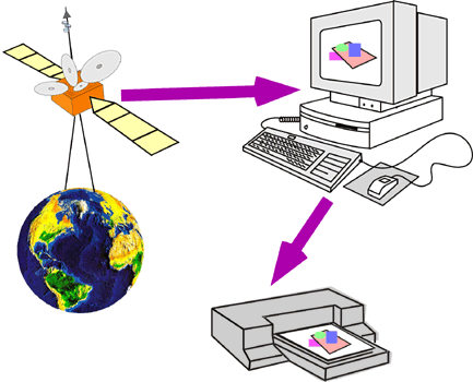

GIS is: specialized software in the management of geographic data


GIS is: issues related to territory
town / state / region / area ecological / natural area / agricultural area
land management : technical, economic ,legal/planning ,landed ,networks
different managers: general Council ,regional Council ,town /diren ,DDAF ,DDAF,dde
gis = decision support
GIS is: actors
- private stakeholders / public players
- local /national actors
services of State /communities territorial /business /providers of data /General public /users data administrator
GIS:
- software
- cast
- equipment
- geographic data
- territory


-Def: a geographic information system and a set of digital data geographically localized structured within a data processing system
comprising functional modules allow:
- create and edit
- question
- question represent cartographically
- a database
- geographic
- according to criteria semantic and spatial.
terminology /GIS related fields:
- Remote sensing
- cartography
- database
- geographic Remote sensing


- Photo interpretation
- field survey DGPS
- statistical geostatistics
- online maps
- Mobile GIS
- treatment images
- System Spatially Referenced Information
- The system of the Territory Information
chapter 2
Examples of using the GIS:
-With the gis, we will :
map /manage /analyze spatially
-the different component of our geographical environment:
forest /urban area /agricultural crop /ground /network transport /network landscape distribution
-the different component of our geographical environment:
forest /urban area /agricultural crop /ground /network transport /network landscape distribution
- cartography Natural Resources
- fleet tracking trucks, trains, taxi
- Emergency Response fire service, ambulance. ..
- mapping and monitoring networks: roads, energy, water, telephone
- Location risk natural and technology
- management of rural areas: agricultural exploitations, parks, forests. . .
- Route calculation
- facilities: rural/ road /rained
- geomarketing
- studies impact
DATABASES ORIGIN OF GIS
SGBD GIS
DBMS: Database Management Systems
Databases as the foundation of GIS: Introduction to DBMS
How is the information in a database?
- users
- process transactions
- database
spreadsheet
/
database
sheet of the
spreadsheet the table in the database


What difference?
-spreadsheet: The spreadsheet is fully charged
RAM: the limited size of data
-spreadsheet: The spreadsheet is fully charged
RAM: the limited size of data
-database: The database works "directly"
HDD: virtually unlimited data size
structure of relational databases:
- database: table 1 -----table2-------table3
- table1 ------recording 1 -------recording 2
- recording 2 -----field 1-----field2-------field3

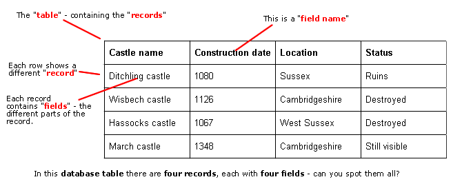
table of relational databases:
The relational model introduced by Ted Codd in the 70:- attribute = field = column
- line recording individual


concept identifier or key:
- id = code uniquely identifies each record in the table
- How many uniquely identify information record in the table?
- duplicates (two or more identical information) are prohibited
- the presence of the key prohibits the presence of an empty field in a record.


why separate the information into multiple tables:
2 types of information in the same table:- owners fields
- vehicles fields
Separation of information into several tables allows
better modularity information that speeds up searches by queries on large amounts of information avoiding unnecessary handling of information
Subscribe to:
Posts (Atom)


