TUTORIAL ARC GIS GETTING TO KNOW ARCGIS DESKTOP
Chapter 6: Manipulate data georeferenced continue
 |
| Tutorial ArcGis: Manipulate data georeferenced part2 |
ArcMap and projections
ArcMap uses the information stored in the projection file or associated georeferencing the various sources of data to compute the display scale data, or to superimpose the entities of the different layers. Ideally, to properly manipulate the data in ArcMap, the projections of information must be indicated.
If one or more layers have no world file, a message appears when adding these layers in the map document indicating that the information is missing.
The projection on the fly
When the user works in a map document, the application selected from the various map projections available to it a coordinate system and any layers affect managed in the document so as to allow the superimposition of the different entities: This is the projection on the fly.
The initial projection data is not changed but is used to allow the superposition of entities.
If one or more layers have no projection file or georeferencing, ArcMap will display a message telling you that it is not able to project broadcast entities of these layers and it is possible that the individual layers do not appear superposed in the display geographical area.
The default projection system
By default, ArcMap affects the geographical display area the projection of the first layer added.
When other layers are added to the map document, they will be automatically projected into the projection default map document.
By default, ArcMap affects the geographical display area the projection of the first layer added.
When other layers are added to the map document, they will be automatically projected into the projection default map document.
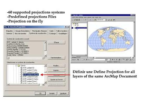
However, the user can define itself its own coordinate system of the hundreds of Predefined files it has. To do this, the Coordinate System tab of the dialog box Block properties used to select the coordinate system that will be used to display area Geographic.
Projections on the fly
When the user works in a map document, the application selected from the various map projections available to it a coordinate system and any layers affects managed in the document so as to allow the superimposition of the different entities: This is the projection on the fly.
The default projection system
By default, ArcMap affects the geographical display area the projection of the first layer added.
When other layers are added to the map document, they will be automatically projected into the projection default map document.
However, the user can define itself its own coordinate system of the hundreds of Predefined files it has. To do this, the Coordinate System tab of the dialog box Block properties used to select the coordinate system that will be used to display area Geographic.
Define work units
Although ArcMap recognizes projection or georeferenced files associated with layers information, it is necessary, when creating a new map document, to indicate the different working units or managed data blocks (s) in the map document.
Without this step, ArcMap is not able to display the data representation ladder or express good distances between entities.
Define work units
This information must be indicated on the General tab of the Properties dialog box for each block of data present in the map document. First, it is necessary to fill in the map units.
This information must be indicated on the General tab of the Properties dialog box for each block of data present in the map document. First, it is necessary to fill in the map units.
These units are directly related to the coordinate system assigned to the data source.
In case of doubt on the unit used for storage of data, check the data dictionary or contact the Data Provider When the map units are filled, it remains to indicate what units you in ArcMap want to work in your document. To do this, simply choose from the dropdown menu Show these units.
ArcMap will use these units during the display of the measures taken in the document.
Tutorial ArcGis


No comments:
Post a Comment