
INTRODUCTION TO
GEOGRAPHIC INFORMATION SYSTEMS
") |
| What is GIS? | Geographic Information System (GIS) |
What is GIS? Introduction to Geographic Information System (GIS)
chapter 1
geographic information is increasingly present in our daily life in -digital form- the geographical location from an address on a website
- Site calculation of geographical routes
- Global Positioning System (GPS) satellite tracking system _car GPS_GPS Hiking
- google earth
- The Geoportal of the ign
- many websites offer interactive maps
YOU MIGHT ALSO LIKE: General Principles Of Gis/Gis: Definitions And Main Functions
What is GIS
S
Système
I d'Information
G Géographique
I d'Information
G Géographique

G
Geographic
I Information
S System
I Information
S System
GIS:
geographic information management for multiple business applications

news geographically localized / geographic coordinates + geographic reference (map projection)
GIS is: computer equipment Specialized computer and peripherals

GIS is: computer equipment Specialized computer and peripherals


GIS is: specialized software in the management of geographic data


GIS is: issues related to territory
town / state / region / area ecological / natural area / agricultural area
land management : technical, economic ,legal/planning ,landed ,networks
different managers: general Council ,regional Council ,town /diren ,DDAF ,DDAF,dde
gis = decision support
GIS is: actors
- private stakeholders / public players
- local /national actors
services of State /communities territorial /business /providers of data /General public /users data administrator
GIS:
- software
- cast
- equipment
- geographic data
- territory


-Def: a geographic information system and a set of digital data geographically localized structured within a data processing system
comprising functional modules allow:
- create and edit
- question
- question represent cartographically
- a database
- geographic
- according to criteria semantic and spatial.
terminology /GIS related fields:
- Remote sensing
- cartography
- database
- geographic Remote sensing


- Photo interpretation
- field survey DGPS
- statistical geostatistics
- online maps
- Mobile GIS
- treatment images
- System Spatially Referenced Information
- The system of the Territory Information
chapter 2
Examples of using the GIS:
-With the gis, we will :
map /manage /analyze spatially
-the different component of our geographical environment:
forest /urban area /agricultural crop /ground /network transport /network landscape distribution
-the different component of our geographical environment:
forest /urban area /agricultural crop /ground /network transport /network landscape distribution
- cartography Natural Resources
- fleet tracking trucks, trains, taxi
- Emergency Response fire service, ambulance. ..
- mapping and monitoring networks: roads, energy, water, telephone
- Location risk natural and technology
- management of rural areas: agricultural exploitations, parks, forests. . .
- Route calculation
- facilities: rural/ road /rained
- geomarketing
- studies impact
DATABASES ORIGIN OF GIS
SGBD GIS
DBMS: Database Management Systems
Databases as the foundation of GIS: Introduction to DBMS
How is the information in a database?
- users
- process transactions
- database
spreadsheet
/
database
sheet of the
spreadsheet the table in the database


What difference?
-spreadsheet: The spreadsheet is fully charged
RAM: the limited size of data
-spreadsheet: The spreadsheet is fully charged
RAM: the limited size of data
-database: The database works "directly"
HDD: virtually unlimited data size
structure of relational databases:
- database: table 1 -----table2-------table3
- table1 ------recording 1 -------recording 2
- recording 2 -----field 1-----field2-------field3

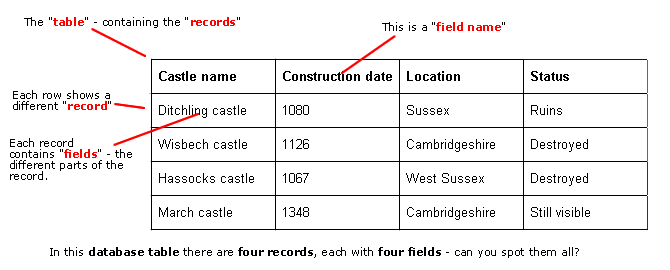
table of relational databases:
The relational model introduced by Ted Codd in the 70:- attribute = field = column
- line recording individual


concept identifier or key:
- id = code uniquely identifies each record in the table
- How many uniquely identify information record in the table?
- duplicates (two or more identical information) are prohibited
- the presence of the key prohibits the presence of an empty field in a record.


why separate the information into multiple tables:
2 types of information in the same table:- owners fields
- vehicles fields
Separation of information into several tables allows
better modularity information that speeds up searches by queries on large amounts of information avoiding unnecessary handling of informationGis/GI


No comments:
Post a Comment